Main menu
Conservation of priority forests and forest openings in "Ethnikos Drymos Oitis" and "Oros Kallidromo" of Sterea Ellada, LIFE11 NAT/GR/1014
Actions
Action A.1: Priority habitat mapping

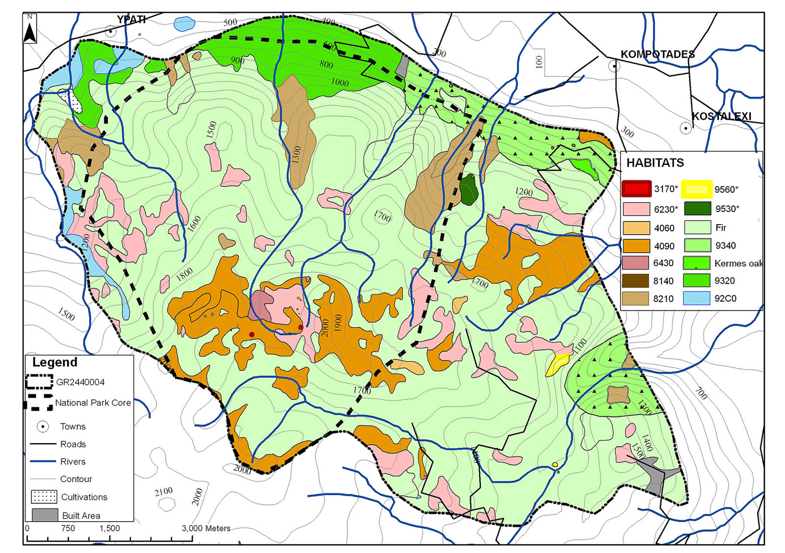
This action includes identification and high spatial resolution mapping of all the target habitats of the project in the sites of Mt. Oiti and Mt. Kallidromo. Mediterranean temporary ponds (3170*), Nardus grasslands (6230*), Pinus nigra forests (9530*), and Juniperus foetidissima forests (9560*) were identified and mapped on Mt. Oiti approximately 10 years ago (1999 – 2000); during the project the existing maps will be updated and new maps will be produced.
Mediterranean temporary ponds (3170*), Pinus nigra forests (9530*), and Festuco-Brometalia grasslands (6210*) will be identified (based on the results of action A.5) and mapped for the first time on Mt. Kallidromo. Differential Global Positioning System (GPS) instruments and Geographical Information System (GIS) software will be used for the survey and map production and update. The high spectral resolution consists of acquiring data in 8 different channels of spectra including the visible, near infrared, but also the 400 - 450 nm part of the spectrum which supports vegetation identification and analysis based upon its chlorophyll and water penetration characteristics.
The acquisition of such data in three different periods will provide a multi-temporal monitoring of the broader area of ponds and grasslands throughout the project duration. In combination with the existing earlier panchromatic air-photographs a full geo-referenced image data archive (see action A6) can be created as a complete base for future reference. The final hardcopy maps will be on a scale of 1:1000 for ponds and grasslands, and 1:5000 for forests, and will include layers with topographic information (including relevant infrastructure such as buildings and roads) and habitat information.
The collected data and the produced geographical data will comprise a digital map and will be published on a network mapping visualisation tool (WebGIS) that can display several thematic layers of geographic information, depending on the user needs. The WebGIS system will be used by the partners to access the data on an interactive digital map throughout the duration of the project, by using an internet connection and loading the website of the project. The high importance of this system stems especially from the quick and accurate projection of the acquired real-time data such as animal movements (tracked in action C3), weather conditions etc. on top of the digital map comprised by the data used for the project. This system is already installed and running on a server placed in the Laboratory of Geophysics at the University of Athens.
The deliverables of action A1 are mandatory tools for planning, implementing and monitoring the conservation actions for the following reasons:
-
High spatial resolution maps of the current distribution of ponds, grasslands and forests and historical maps will be used in order to assess the process of fir forest expansion at the expense of grasslands and ponds (action A6). Based on this, specifications for action C3 and the initial status for monitoring (actions D1, D2) will be drawn. The existing habitat maps for Mt. Oiti are more than 10 years old, and of too small a scale for the assessment of the relative areas of trees/grasslands/ponds. There are no habitat maps for Mt. Kallidromo.
-
Habitat maps will: contribute in the sampling design for actions A3 and A5; supply the current area of habitat 9560 for action A7 and the initial status necessary for monitoring in action D3; contribute in the sampling design which will produce specifications for action C5; provide data for action A8 in order to select the exact locations and define the area for action C1 subactions.
-
Multi-temporal monitoring and the WebGIS tool will be used in: actions D1 and D2; monitoring animal movements in action C3; monitoring weather conditions which will help in scheduling actions C2 and C4.
-
The WebGIS tool which will be used in action E3 will also facilitate communications between partners (action F1).
-
High spatial resolution habitat maps can be used, along with satellite images, in order to assess even comparatively small changes in habitat area and will be an efficient tool for after-LIFE monitoring. In addition, the use of new tools for monitoring and visualising collected data will lead to a more systematic and technologically updated organisation of the knowledge about study sites. In particular, the use of newly available GIS technology in small pond monitoring is a demonstration action. If the technique proves efficient, it will facilitate future monitoring by reducing recurring field work.
-
Two high resolution maps of the target habitats, one for Mt. Oiti and another for Mt. Kallidromo, in printed and electronic form.
-
Remote sensing image time-series of the area of interest, for detection of environmental changes, as well as quantification of the possible changes.
-
High resolution reference image and 3D representation.
-
Collection and unification of all data, including real-time data, in a network based GIS system for instant reference between the project partners.


